Week 8 Mass Wasting Events
Week 8: Mass Wasting Events
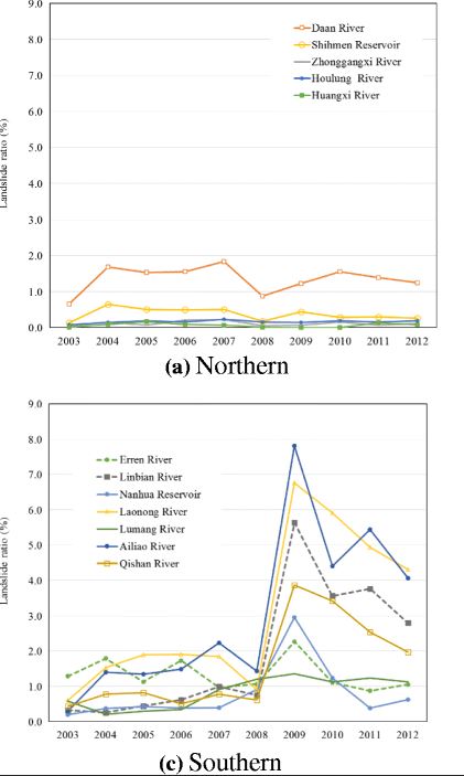
This week we will discuss a mass wasting event in Taiwan. Taiwan is one of the countries prone to landslides due to a combination of rapid rainfall events, typhoons, and periodic earthquakes. According to my research, the landslide probability in Taiwan was 0.5% to 2% until 2009.
https://blogs.agu.org/landslideblog/files/2017/05/17_05-Taiwan-1.jpg
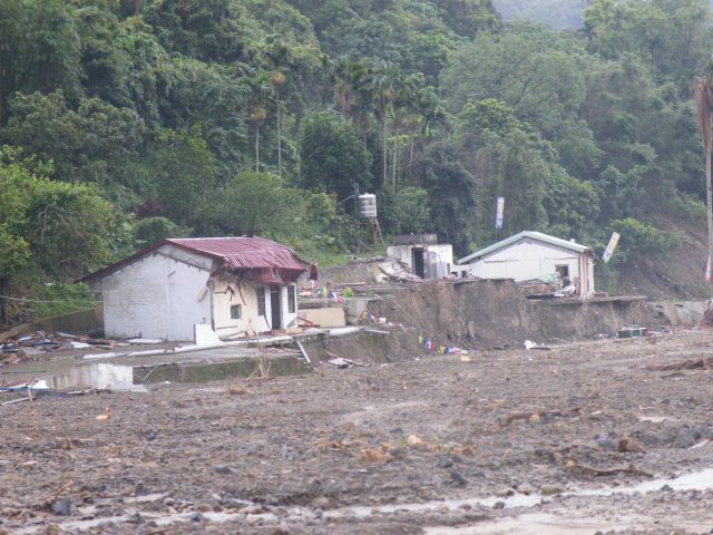
However, after 2009, a drastic change occurred in southern Taiwan and the landslide rate increased dramatically. Northern Taiwan was unaffected, but southern Taiwan was hit by typhoons that brought massive amounts of rainfall, resulting in horrific landslides. Taiwan is prone to typhoons due to the winds, with many typhoons occurring offshore in areas east of Taiwan or south of Japan. 2009 saw Typhoon Morakot, in which more than 700 lives were lost due to the typhoon. 2010 also saw a landslide that partially buried a highway, killing several people. There have been other disasters as well.
https://blogs.agu.org/landslideblog/files/2017/05/DSCF0437-e1494486516498.jpg
Taiwan is very prone to extreme weather, and one must always be prepared for landslides, floods, and landslides. For those countermeasures, if you are going to Taiwan, it is important to remember to check whether the area is safe or not, to check the routes to evacuation centers and shelters, and to prepare advance food and machines that can obtain information quickly in case of evacuation. If a disaster occurs, it is easy to panic because the forces of nature cannot be controlled by human power, but remember to take a deep breath and do all you can to protect your life by remembering what you have confirmed well in advance.

https://www.researchgate.net/publication/342634314/figure/fig1/AS:908836919574538@1593695015994/Morakot-driven-rainfall-and-landslides-in-Taiwan-a-Hillshaded-map-of-cumulative.jpg
Sources:
https://blogs.agu.org/landslideblog/2017/05/11/taiwan-landslide-hotspots/
https://www.bbc.com/news/world-asia-pacific-11767173


Hello Shoki,
ReplyDeleteI really enjoyed your in depth post about the natural disasters that occur within your country. One of them that really caught me off guard was the fact that your country was seemingly hit by a wave of typhoons that in turn affected the post weather. Such as the rain and humidity increase, its really interesting to read about and thank you for sharing.